
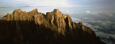
Mt Kinabalu Eastern Ridge
My meeting with Prof Ho is documented at Arkitrek under the post of his name. Another fascinating thing for me about Prof. Ho is that he was a member of the 1964 Mt Kinabalu East Expedition during which Prof. E J H Corner of Cambridge University made the third ascent of Kotal’s Route to the Eastern Plateau of Mt Kinabalu. This is the route that I followed in complete ignorance with friends Emma and Matt in June 2004. The account of that ascent follows.
* * * * *
The rotting branch takes on a fresh intensity as I decide to trust my weight to it. It appears to be held together by lichen. My senses are heightened perhaps by the gathering dusk and the fact that after nine hours on the go, we still haven’t reached the campsite and water source that our tireless guides have promised. Unexpectedly we find ourselves at the edge of a granite outcrop that affords a momentary viewpoint. My mind alights on the precipitous angle of the jungle and far below tufts of white cloud soak up the last of the day’s light. For a moment I forget my fears and enjoy being alone on the eastern flank of Mt. Kinabalu with my better half Emma and alter ego Matt.
Our route started in the fields above Kundasang where Sammy’s father in law owns a prizewinning cabbage farm. Sammy put this trip together for us including permits, transport, our mountain guide Jusirin and porter Maudin. Jus is the younger of the two, short, stocky and with a touch of the showman. Din is quieter, also short but strong and wiry with remarkable stamina. They only speak a word or two of English but we soon establish a rapport based on the word ‘bagus’ (good).
At the top edge of the cabbage fields Jus and Din confer briefly before leading us into apparently trackless jungle. Our progress is slow and clumsy as we learn to deal with thorny rattan and frustrating bamboo thickets. Juicy pitcher plants grow beside the trail and the flaking trunks of gnarled trees are home to bright green moss and hanging epiphytes. We climb for an hour or so before the ground collects itself into an exposed ridge that we follow until it dips abruptly to a col. The montane rainforest is more stunted here and we are granted glimpses of all embracing mountainside.
It is getting late and our guide’s animated discussion is presumably on the subject of where to spend the night. We pass a number of campsites but they are all rejected on the grounds of ‘tidak air’ (no water). Pushing on through a particularly gloomy thicket we emerge in a small glade on a ridge from where I can hear a waterfall off to one side. Jus and Din have already taken off their sacks and are enthusiastically photographing each other.
With the tents up, our guides collect waterbottles and head off to find the waterfall. They see this as their job and ‘no,’ there is no need for us to accompany them. This annoys Matt and me who would both like an opportunity to explore our new environment. Emma does not have so much energy to spare, but then she has only recently arrived in Borneo and has not spent the last four months doing strenuous volunteer work. We console ourselves by ransacking food from Din’s modified rice sack that he uses as a rucksack.
After breakfast we pick up a trail leading straight uphill out of our camp. We climb steadily all morning and the vegetation requires us to either clamber over large fallen branches or crawl through tunnels of rhododendron. At our lunch spot I am excited to be able to pop my head up above the dwarf canopy and see pinnacles of smooth granite ahead. These I later identify to be the Mesilau Pinnacles, as yet unclimbed. Right now though I have no idea of the topography of the mountain, we don’t even have a map or compass. Our only sources of information are our eyes, Matt’s altimeter and our eloquent guides.
This ignorance has become intrinsic to our whole expedition. Two months earlier Matt and I asked Sammy if he knew whether it was possible to climb Mt. Kinabalu by a route that would avoid the tourists and that would take several days to allow for comfortable acclimatization. ‘Eastern Ridge,’ said Sammy after his preliminary research, ‘It takes six days and does not go to Lowe’s Peak.’ He added that the climb would require written permission from Sabah Parks and that we would need to find a mountain guide who knew the route. Furthermore he warned us that we might not be permitted due to lack of water on the route and unknown condition of fixed ropes. ‘But don’t worry,’ he said, ‘I’ll do all the arrangement for you.’
For aspiring adventurers this description was irresistible. Matt and I immediately signed up and I put Emma’s name down too. The fact that she had no idea what I was getting her into worried me a little. The combination of rainforest and a spectacularly steep mountain guaranteed that this would be a challenging climb. With no research to make up for our naivety, we were all three signing up in blind faith. In fact Emma was signing up in blind faith on my blind faith.
‘But don’t worry,’ we had assured her, ‘this is the way things work in Sabah, everything will sort itself out.’
The fact that she didn’t put her foot down implied acceptance of the plan, or lack thereof, and that we were all in.
I am a little disappointed when we head downhill, away from those alluring pinnacles. ‘Need water’ we are told. ‘No water here.’ We skirt the base of the pinnacles until it is possible to descend into a dry gully bed.
‘Tidak air,’ announces Jus, confirming the obvious.
‘OK, where is air?’ I try not to sound impatient or concerned.
‘Next one.’ By which I presume he means the next watercourse.
Ironically it starts to rain and I’m not sure whether to put some more clothes on or to spread out our tent flysheet to catch water? Jus and Din also appear uncertain and are quartering the hillside presumably looking for a trail that will lead to the ‘next one’. No sooner have I made my decision they find the trail contouring an improbably steep spur that bounds our gully.
We scramble up and down over tree roots and boulders, traversing the mountainside in a pattern that will inevitably bring us into another drainage. Again we hear ‘tidak air’. It’s getting late and Matt and I are grinning at each other in a ‘this is starting to get interesting but we’re game for it’ kind of manner. Matt and I may be game but Emma lets it be known that she’s flagging. I wonder how much she has left. I have found through experience of climbing with women that they tend to hold more in reserve than they let on. This compared to men for whom the converse is often true. I hold onto this thought and pray that tiredness does not result in accidents.
We should have found a campsite by now but we continue, descending a gully choked with logs and boulders. We’re moving away from that smooth granite toward steaming jungle ravines of indiscernible depth. We descend by lowering ourselves from mossy roots onto footholds of crumbling humus. I have twigs down my back from stooping under branches and my knees are filthy from crawling. We pass a good flat camping site. Tidak air of course and it’s onwards and downwards. At the end of the day it gets dark and even our guide has to admit that we will have to camp with tidak air. ‘Tidak bagus’ (not good) mutters Matt. We chop out a small ledge from the moss and roots and manage to get two thirds of the tent onto it. After dinner of tuna mayo with crackers washed down with peanut butter, we mix the last of our water with some rehydration salts and pass the mug around.
Conversation before bedtime revolves around how we have got into this situation and now that we’re here, what can we do to about it. We all feel the need to talk but it is clear that we have few options and that we can take no decisions until morning. It’s to be a sleepless night characterised by a sticky throat and dreams of clear flowing rivers.

That morning we are greeted by the concerned faces of our guides. I try to communicate the question ‘where will we find water?’ we are assured that, ‘over there,’ is water. ‘Over there’ could be either on the facing hillside or around the corner into another watercourse. What they do make clear however is that neither our path nor any other path continues down, which would seem to me to be our best tactic for finding water. This fact also unsatisfactorily answers Emma’s growing concern, where is our escape route?
It is nine hours back to the last known water and there is no alternative route down. We have no choice but to continue. After half an hour’s walk we reach a drainage that guards a trickle of water. It takes five minutes to fill each waterbottle but we soon have enough to brew up some noodles. With the help of a Malay phrasebook and some hasty diagrams we try to thrash out a map and itinerary for the way ahead.
‘Tonight, good water. Bagus air,’ Jus tells us emphatically.
‘And then the next night also bagus air?’ we ought to have established these basic facts when we had Sammy around to translate.
‘No, no good water there,’ replies Jus. It is clear that there is no point in taking this conversation further. We bend down to start packing our rucksacks and in doing so make a tacit agreement to continue.
Jus recognises the moment and utters the call to action. ‘Bagus?’
‘Bagus,’ we dutifully echo. Matt looks at me and rolls his eyes.
‘Jalan naik bukit’ (the path goes uphill) adds Jus in case there was any doubt.
Uphill it is, through larger trees that thankfully allow me to climb without a stoop. As the forest dwindles into giant heath we reach a vantage point where we decide to have lunch. As soon as we have set out our food it starts to rain heavily. We pull out our tent flysheet for shelter but are already soaked and shivering. Matt finds a reserve of energy and busies himself brewing Maggi noodles that go a long way to restoring moral. With the rain easing back to a drizzle we set off again, this time downhill.
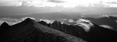
After crawling through another rhododendron tunnel we emerge on a vague ridgeline from where more pinnacles appear through the mist.
‘Eastern Ridge.’ Announces Jus.
As this is the supposed name of our route, you might forgive me for assuming that we would be climbing the Eastern Ridge. Instead we cross the ridgeline and descend away from the pinnacles. Through gaps in the clearing mist I can see far below to where granite waterslides cascade out of sight into a deep green ravine. I begin to suspect that the headwaters of this steep sided valley might be the bagus air of tonight’s camp. To reach them we must zigzag down vegetated ledges between blank walls of granite, at times using a rope to lower ourselves hand over hand down awkward sections.
Steadily the sound of the cascades draw level and I begin to wax about how committing this route has become. How with commitment comes the surety to perform feats that you would not contemplate if it were easier to back out.
‘Uh oh! This looks interesting.’
I see water falling down a brown mossy slab. This in itself is unremarkable but with the addition of a knotted rope tied to a tree, the waterfall takes on a new significance. Jus swings over the edge first. Sure-footed in cheap plastic plimsolls he is soon at the bottom some eight meters below. Next goes Matt and I watch absent-mindedly, distracted by concern for Emma.
‘Hey! Where’s that camera?’ demands Matt.
Of course he wants his photo taken, he is about to lower himself hand over hand down what I would normally consider a respectable abseil. With Matt safely down Jus comes back up and takes Emma’s rucksack. I offer to belay with the spare rope that Jus is carrying, but of course she is more confident than she is letting on. I suffice with some words of advice and then commit myself to a demonstration. Emma follows in fine style and it is not long before we are trying to decide which of two flat mossy patches of grass to put our tent on.
Later I learn that we were in the upper Mekado Valley, baby brother to the infamous Lowe’s Gully, which is to our west and separated from us by the North Peak. Standing in this arena of converging mountainsides I am overcome by a feeling of aloneness. The light fails and clouds roll in from the foothills. It is getting cold and tomorrow we have a long climb to reach the puncak or peak.

The next morning does not start gently. We have not been out of the camp more than five minutes before I am relying on the friction of my boots and the tenacity of moss to prevent a painful slide down a granite slab. One particularly bold move involves climbing the lower branches of a tree in order to reach an elevated root system hanging from the next ledge.
As we climb higher the vegetation thins out and the dry rock is a delight to scramble on. We emerge on the easy angled plateau slabs and the clouds part to reveal improbable rock spires looming above us. This provokes an exuberant photo shoot from Jus and Din. Just below 4000m we reach the watershed and look down the other side of the mountain.
‘Puncak!’ announces Din, gesturing up the mildly angled slabs.
Puncak means peak, but from our earlier ‘conversations’ we had also come to understand it to mean the place we are to camp tonight.
We find water in a small rock pool and after some debate choose a rocky patch of moss for our tents. With plenty of afternoon left and the puncak so close we convince ourselves to take a quick look, despite the unpredictable clouds. As it happens we reach the summit in sunshine but the mountain still makes no sense I ask Jus where is Lowe’s Peak? To which he points proudly into a rising stack of cumulonimbus. I can see that I am going to have to wait until morning for everything to become clear.

At 4.00am I can tell by their breathing that the others are wide-awake concentrating on sleeping. There is seldom frost on Mt. Kinabalu and so getting out of my sleeping bag is not as hard as I’d feared. The morning is most notable for the fact that Emma and Matt have come down with a dose of the trots during the night. For the first time on the trek I find myself overtaking Matt on the short climb to the puncak. He does not make it to the top immediately but stops to compose himself 50m short. Emma makes it but excuses herself moments later.
Before me is the dark defile of Lowe’s Gully and across the gulf I identify Lowe’s Peak by the strobe of camera flashes on the summit. The sun makes its appearance and I take a break from brewing noodles to photograph alpenglow on rock. Through gaps in the cloud carpet I can see the coastline of the South China Sea curving northwards from Kota Kinabalu. I am happy when Matt finally drags his sorry self to the top and the three of us share a smug feeling that we’re here and everyone else is over there.
Of our route down, I have no idea. It is hidden by the slope horizon. From the separation to Lows Peak it is obvious that it will be some time before we join the tourist path. Our descent begins on easy angled plateau slabs that lead rightwards to avoid a big drop below. It is obvious that we are looking for a ramp that will lead us through the band of cliffs that prop up the plateau. I am not surprised to find that this ramp is steep enough to warrant fixed ropes. Unlike the previous fixed ropes, these ones are underlined with significant exposure culminating in an airy traverse and fixed ladder performed above a whole lot of nothing. I hold tightly onto the hawsers and concentrate on my footwork, trying to avoid over reliance on the dubious bolts. Meanwhile our guides are loving it and Jus whoops with bravado for the benefit of the crocodile of punters on the tourist path, now visible half a kilometre to our right.
Reaching the tourist path involves more scrambling and proves something of an ordeal for Matt and Emma, whose stomachs are suffering. It takes another hour to reach the sanctuary of the Laban Rata Guesthouse at 3200m. Here we plonk our weary selves down and tuck into crackers with tuna and a mug of Milo. It is 9.00am and we need to gather our strength for the five-kilometre walk to the roadhead at Mesilau. For Matt and Emma this walk through luxuriant rainforest must feel like a cruel trial of endurance. I selflessly take great care to enjoy it on their behalf.
One week later, on our return to Kota Kinabalu, I learned that the name of our puncak is King George and that it is 4063m high.
Related Posts
%RELATEDPOSTS%