
Logging Maliau Basin buffer zone
I have learned from several sources that the buffer zone to Maliau Basin is to be logged again. It’s unclear as to the extent of the logging but I’ve been told that it will affect the area around the access road, between the gate and the studies centre.
The Maliau Basin Conservation Area Management Plan allows for the buffer zone to be logged once more using reduced impact logging (RIL).
So far Yayasan Sabah (YS) have only formally implemented RIL on one small experimental plot near Danum Valley Conservation Area.
In the early days of logging in the Yayasan Sabah concession, much of the harvesting did have a reduced impact due to the highly selective nature of the extraction.
Latterly YS seem to have lost control over their contractors and we have witnessed virtual clear cutting. The Ulu Segama Malua area is a case in point. See my earlier post.
Clear cutting is more likely to occur in areas that have already been logged several times. This is because there are fewer large trees left to ‘select’. Without these large trees, a greater volume of smaller trees must be harvested in order for the forest reserve to be as profitable as it used to be.
Greed is overcoming sustainable forest management.
Despite these pressures, Yayasan Sabah has managed to keep most of it’s concession under natural forest cover to varying degrees. In other parts of the state much of the natural forest has now been replaced by plantation.
This conversion is starkly illustrated by the google earth image below which shows part of the southern boundary of the Yayasan Sabah Concession. Dark green natural forest above contrasts with ligther green plantation (mostly oil palm) below.
Yayasan Sabah however is not immune to these commercial pressures. Most of their concession is still forest reserve because that is its legal land use zoning. The process of alienating state forest reserve into private agricultural land is a complex process, but not impossible
The google earth image below shows part of the YS concession, formerly designated forest reserve but now cleared for a 19,000ha softwood plantation.
The buffer zone to Maliua Basin Conservation area is highly visible forest with high conservation value. This area supports one of the few remaining wild populations of the wild cattle known locally as tembadau.
Yayasan Sabah has been at the forefront of innovative forest management, starting in the 70’s when the logging was a low intensity, continued in the 90’s when they traded carbon offsets for forest regeneration and most recently, forest regeneration through the sale of biodiversity credits from the Malua Biobank.
The latter however came only after the environmental disaster at Ulu Segama Malua that I have mentioned.
Payments for ecosystem services (as carbon and biodiversity credits are known) is still in its infancy and heavily reliant on voluntary codes.
While governments, NGO’s and industry haggle over terms, the forest is still being cleared.
If forest is over exploited now it will become more expensive to regenerate in future, regardless of whether the investment comes from sustainable forestry or ecosystem services. In this case the only viable economic alternative may be conversion to plantation.
The google earth image below shows the distinctive caldera shaped Maliau Basin, picked out by the cloud clinging to its north eastern rim.
Maliau Basin is still connected by contiguous natural forest to other conservation areas such as Imbak and Danum, plus the remote jungles along the Kalimantan border known as The Heart of Borneo.
It is important to their viability as conservation areas that they remain connected.
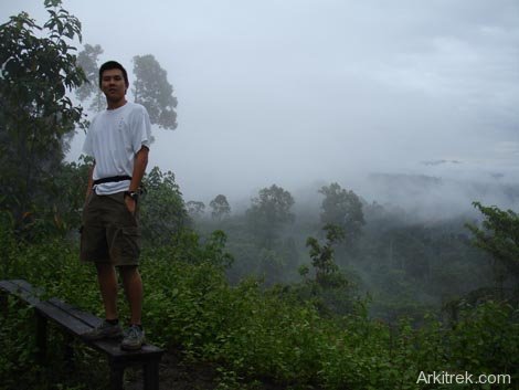
An Everyday Junglist surveying the Maliau Buffer zone that is to be logged.
Related posts


Logging Maliau Buffer Zone – update
A source has confirmed that the above mentioned logging will affect an area of 7000ha in forest that was last logged in 1996.
Even if RIL was strictly adhered to in 1996, 12 years does not seem like enough time for the forest to regenerate.
It looks like the future for the entrance approach to Maliau Basin is forest that is so badly degraded that it can not regenerate in a sensible timeframe.
This habitat is great for elephants but disappointing on most other counts; including the perception of visitors, researchers and tourists to have come to observe the pristine Rainforest of Maliau Basin.